Unearthing the Enigma: Decoding the Ancient Astronomical Secrets and Multifaceted Purpose of the Nazca Lines
Curioscope’s Lens
At Curioscope, we are humbled by the sheer ambition of the Nazca Lines. Imagine the conviction required to spend a lifetime moving stones to create a drawing you will never see in its entirety. It challenges our modern obsession with instant feedback. For the Nazca people, the act of creation was faith itself—a message not for human eyes, but for the sky. Were they praying for rain, or marking the passage of time? Perhaps the lines themselves are the answer: a testament that humanity has always sought to be part of something larger than the earth beneath our feet.
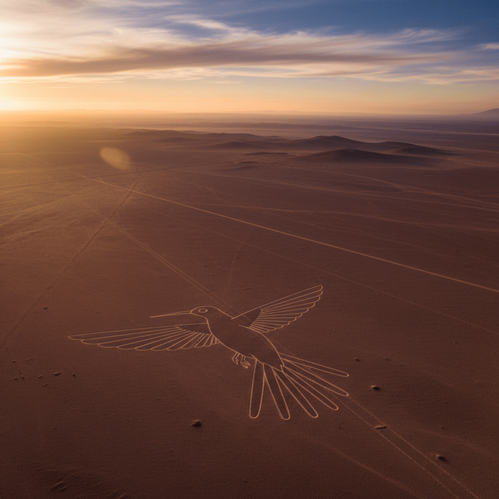
The Nazca Lines, monumental geoglyphs etched into the desert floor of Nazca, Peru, spanning hundreds of square kilometers, represent one of humanity’s most captivating mysteries. These etchings, depicting animals, plants, geometric shapes, and straight lines, have puzzled observers for nearly a century. Theories range from simple ritualistic drawings to sophisticated astronomical calendars reflecting the advanced scientific understanding of the ancient Nazca people. Recent research employing cutting-edge technology and interdisciplinary approaches aims to uncover their true purpose.
Historical Context and Discovery
- The Nazca Lines were unknown to the wider world until the advent of flight in the early 20th century.
- Pilots in the 1920s and 30s reported seeing colossal figures from the air.
- The geoglyphs cover approximately 450 square kilometers between Nazca and Palpa.
- The arid plateau’s lack of wind and rain has ensured their remarkable preservation for over 2,000 years.
Creation and Dating
Dating: Between 500 BC and 500 AD, created by the Nazca culture (pre-Incan civilization).
Method: Removal of reddish-brown iron oxide-coated pebbles to expose lighter subsoil.
Scale and Precision: Lines vary from centimeters to over a meter wide. Designs span hundreds of meters with remarkable straightness over undulating terrain, posing a question about how they were achieved without aerial vantage points.
Types of Geoglyphs
- Biomorphs: Depictions of animals (hummingbirds, lizards, monkeys, pelicans, fish, sharks, orcas, spiders), plants, and stylized human-like figures (e.g., “the Astronaut”). Sizes range from tens to hundreds of meters.
- Geometric Shapes: Trapezoids, triangles, rectangles, spirals, zigzags.
- Straight Lines: Thousands of lines, some extending for many kilometers, often converging at specific points, forming complex networks.
Early Theories
- Religious/Ritualistic: Pathways for ceremonial processions, offerings to gods, early writing or communication.
- Water/Fertility: Depictions of animals associated with water or fertility in Andean cosmology, linked to rituals to invoke rain in the arid environment.
Maria Reiche’s Pioneering Research
German mathematician and archaeologist who dedicated over 50 years (1940s-1998) to studying and protecting the lines.
- Systematically surveyed, measured, and mapped the geoglyphs.
- Hypothesis: Many lines and figures served as an enormous astronomical calendar, marking solstices, equinoxes, and celestial events.
- Advocacy led to their designation as a UNESCO World Heritage Site in 1994.
Scrutiny and Alternative Theories
- Critique of Astronomical Hypothesis: Insufficient evidence for consistent, widespread astronomical purpose; alignments could be coincidental due to the sheer number of lines and possibilities.
- Water Management and Irrigation:
- Connections to puquios (underground aqueducts).
- Geometric shapes (trapezoids) interpreted as markers or reservoirs for water rituals or collection.
- Lines potentially marking water flow, agricultural lands, or sacred water sources.
- Ritualistic or Social Functions:
- Delineation of sacred spaces for ceremonies or fertility rites.
- Animal figures as part of shamanic rituals or offerings.
- “Astronaut” figure as a shamanic deity or ritual participant.
- Territorial markers or indicators of clan identity.
- Extraterrestrial Involvement: Popularized theory (e.g., Erich von Däniken) lacking credible archaeological evidence and dismissed by mainstream academia.
Methodologies of Creation
- Tools: Ropes, stakes, rudimentary surveying instruments.
- Technique: Scaling up smaller models, using radiating lines from central points for precision.
- Experimental Archaeology: Demonstrates feasibility with ancient technologies, requiring planning, labor, and geometric understanding.
- Preservation Factors: Desert climate and composition (dark surface absorbs heat, creating a warm air cushion protecting subsoil from wind and erosion).
Modern Research and Technology
- Technologies: Drones, satellite imagery, 3D scanning, AI-driven analysis.
- Discoveries: In 2018, Japanese researchers (Yamagata University) used drones and AI to discover over 140 new geoglyphs.
- Spatial Analysis: GIS mapping reveals relationships between geoglyphs, settlements, water sources, and ancient roads.
- Refined Astronomical Hypothesis: Modern archaeoastronomy uses rigorous statistical methods; some compelling correlations with solstices and bright stars found, but not overwhelmingly supporting a solely astronomical function.
Multifaceted Purpose
- Increasingly unlikely that a single explanation exists.
- Likely served various functions simultaneously or evolved over time.
- Potential integrated purposes: astronomical calendars, ritual pathways, water source markers, clan identity symbols.
- Different geoglyph types may represent distinct purposes.
- Holistic worldview of the Nazca people, linking sky, earth, and human endeavors.
Preservation Challenges
- Fragility: Susceptible to damage from foot traffic, vehicles, environmental changes.
- Threats: Illegal mining, farming, extreme weather events (climate change).
- Conservation Efforts: Strict regulations, drone monitoring, public awareness, sustainable tourism.
- Tourism Management: Balancing economic benefits with minimal environmental impact.
Conclusion
The true purpose of the Nazca Lines remains a profound enigma. While Maria Reiche’s astronomical hypothesis was influential, modern research suggests a more nuanced, multifaceted explanation. The lines likely embodied a synthesis of meanings deeply ingrained in the Nazca worldview, including astronomical, ritualistic, agricultural, and social functions. They stand as a testament to the ingenuity, spiritual depth, and complex understanding of the natural world by an ancient civilization. The ongoing quest to decode these etchings continues to reveal insights into humanity’s fascination with the heavens and the pursuit of meaning in ancient legacies. The Nazca Lines are a grand, unsolved puzzle inviting future exploration.
Editor’s Reflection
Walking the path of the Nazca Lines is to walk a line between science and wonder. We have dissected the soil, mapped the stars, and flown drones over every inch, yet the silence of the desert keeps its final secret. Perhaps that is the lines’ greatest gift: they force us to admit that not everything can be explained by data points. They stand as a monument to the human need to communicate with the infinite, a silent prayer etched in stone that has outlasted the gods it was meant to honor.
Test Your Nazca Knowledge!
1. The Nazca Lines are easily visible and recognizable from the ground level without the aid of flight.
2. Maria Reiche was a pioneering researcher who extensively studied the Nazca Lines and proposed they had astronomical significance.
3. The Nazca Lines were created using advanced laser technology by an extraterrestrial civilization.
Beyond the Veil: Unpacking Reddit’s Obsession with UAPs, Cover-ups, and the Search for Truth